
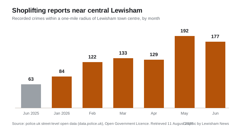
Police logged 177 shoplifting reports within a mile of central Lewisham in June 2026, up from 63 a year earlier. Total recorded crime rose 16 percent to 1,200.
Shoplifting recorded around central Lewisham has almost tripled in a year. The latest street-level figures published through police.uk log 177 shoplifting reports within a mile of Lewisham town centre in June 2026, against 63 in June 2025. June is the most recent month in the published data, which covers crimes within a one-mile radius of a single point; Lewisham News pulled the figures from the police open-data service on 11 August.
Total recorded crime in the same circle rose 16 percent over the year, from 1,033 offences in June 2025 to 1,200 in June 2026. Violence and sexual offences remained the largest category at 340 reports, up from 315 a year earlier, while anti-social behaviour edged down from 232 incidents to 221.
A climb through 2026
Shoplifting has risen through the year, not just against last summer. The monthly counts for 2026 so far: 84 in January, 122 in February, 133 in March, 129 in April, a peak of 192 in May, then 177 in June. Every month since February has been roughly double or more the 63 reports of June last year.
Other categories moved too. Vehicle crime rose from 42 reports in June 2025 to 72 in June 2026, burglary from 24 to 44, robbery from 19 to 36 and bicycle theft from 8 to 28. Theft from the person went the other way, down from 42 to 27. One category needs treating with caution: criminal damage and arson shows just 2 reports in June 2026 against 56 a year earlier, a fall so sharp in a single category that it is more likely to reflect how reports were recorded or mapped than a real change on the street. The service itself warns that “inconsistent geocoding policies in police forces mean we cannot be confident that the location data provided is fully accurate or consistent” (data.police.uk, about the data).
Where the reports cluster
The single biggest cluster of June’s shoplifting reports, 85 of the 177, is mapped “on or near Petrol Station”, with 27 near Eastdown Park, 24 “on or near Shopping Area” and 22 “on or near Supermarket”. Those labels do not identify any actual premises. To protect privacy, each report is snapped to one of a national list of anonymised map points, which are centred on streets, public places or commercial venues and named after the nearest landmark type, so a point labelled “Petrol Station” simply means reports from that part of the town centre are gathered at a marker near a petrol station, not that any particular business was the scene.
The figures count crimes recorded by the Metropolitan Police, not outcomes: they say nothing about charges or convictions, and a rise in recorded shoplifting can reflect more reporting by stores as well as more offending.
What it means for you
The same open data covers every street in the borough, and you can check your own road rather than the town-centre circle we used: enter your postcode at police.uk’s your-area service to see recorded crimes, the local ward panel and the officers for your neighbourhood. Shoplifting in progress should be reported on 999 if someone is in danger, otherwise to the Met on 101 or online. We will look at the July figures when they are published, and at whether May’s peak of 192 was the top of this rise or a step on the way up.
Have your say