
Kirkdale, Baring Road and 26 more are on Lewisham's 2026/27 resurfacing list. The £6.9m programme also funds five new Healthy Neighbourhoods in design.
Lewisham Council has published the list of roads it plans to resurface in 2026/27, and the wider transport programme they sit in. The 2026/27 Strategic Transport and Highways Capital Programme was agreed by Mayor and Cabinet at its meeting on Wednesday 9 September. The printed decisions, published after the meeting, confirm the programme was agreed as detailed in the report, with any traffic management orders needed for delivery delegated to the Director of Public Realm.
The programme is worth about £6.9 million across four funding pots. The report asks the Mayor and Cabinet to:
- agree the year’s projects, including £3,809,259 for resurfacing and pavement works
- spend a £2,557,000 Transport for London grant on safety, bus, cycling and walking schemes
- put around £437,336 of developer contributions into schemes at Bell Green and elsewhere
- delegate any traffic orders needed to the Director of Public Realm, so individual restrictions will not come back for a separate political decision
The full road lists are at the bottom of this page. Both are provisional: the report says any road that cannot be done in 2026/27 moves to a reserve list for 2027/28.
Five new Healthy Neighbourhoods, all in the north of the borough
The most consequential item is the start of five new “Healthy Neighbourhoods”. These are area-based schemes funded by TfL’s Safer Corridors and Neighbourhoods programme, which the report describes as making streets “safer and healthier by reducing road danger, improving air quality, and encouraging walking, cycling, and public transport use”.
None is being built yet. This year’s money buys design and feasibility work:
- Creekside (£59,000, feasibility): between the Greenwich boundary and Deptford Church Street
- Kender (£172,000, preliminary and detailed design): between New Cross Road, Queen’s Road and Pomeroy Street
- New Cross Gate (£114,000, feasibility): between the Southwark boundary, the Surrey Quays to New Cross Gate railway line and New Cross Road
- St John’s and Tanners Hill (£190,000, preliminary and detailed design): between New Cross Road, Amersham Road, Lewisham Way, Rennell Street, Lewisham High Street and the DLR line
- Telegraph Hill (£115,000, feasibility): between Queen’s Road, New Cross Road, Lewisham Way, Malpas Road, the Endwell Road, Drakefell Road and Gellatly Road line, and Lausanne Road
That is £650,000 of design work concentrated in Deptford, New Cross and Telegraph Hill. Kender and St John’s are furthest along, at detailed design. The report does not give construction dates, and any restrictions would need traffic orders first.
School Streets: two new, one upgraded, four monitored
Two new School Streets are funded through to construction this year:
- Good Shepherd RC School, Moorside Road, Downham (£97,000)
- St James’s Hatcham Church of England Primary, St James’s, Brockley (£36,000)
The existing School Street at St John Baptist Church of England Primary gets an upgrade, paid for from developer contributions. Four delivered schemes move into post-implementation monitoring: Drumbeat School on Roundtable Road, Prendergast Vale on Elmira Street, St Michael’s Church of England Primary on Champion Road, and Turnham Academy with Chelwood Nursery on Turnham Road.
Walking and cycling: Catford underpass, Cold Blow Lane, Hither Green link
- The Catford Bridge underpass under the A205 South Circular, beside Catford and Catford Bridge stations, gets a £165,000 upgrade, funded to construction.
- £230,000 completes the Bridgehouse Meadows to Cycleway Q14 route via Cold Blow Lane: quick-win works at Dragoon Road and Gosterwood Street, making the experimental restrictions on Cold Blow Lane permanent, and a link through to Woodpecker Road.
- £50,000 builds the Limes Grove to Lee station walking and cycling route via Hither Green station.
- £50,000 starts feasibility work on a route from Lee High Road to Grove Park at Chinbrook Meadows.
- £100,000 funds detailed design for road danger reduction at the Brockley Cross and Endwell Road junction and along the B218 through Brockley Road, Stondon Park and Brockley Rise to the South Circular.
- £86,000 buys new cycle hangars on residential streets, and £75,000 delivers dockless e-bike parking bays.
Buses: a £500,000 study, and Honor Oak Park fixed
The single biggest TfL-funded line is £500,000 for the Southeast Bus Transformation, a feasibility and early design study of bus priority and interchange improvements along the A2212/B212 and A2218/A212 corridors.
Design work also starts on bus priority along Brockley Grove and Ladywell Road between Henryson Road and Lewisham High Street (£70,000), and on Sydenham Hill and Sydenham Rise (£40,000).
One long-running problem is recorded as fixed. The junction of Stondon Park and Honor Oak Park has been rebuilt to remove the unsafe left turn that was forcing buses off their route, and buses have returned to it. The scheme is now in monitoring.
Bell Green, Watson Street and the Foreshore
Developer contributions fund three public realm schemes:
- Bell Green gyratory: £336,473 for preliminary design of walking, cycling and traffic management improvements
- Watson Street, Deptford: £93,176 for streetscape works outside the development there
- Foreshore, Evelyn ward: £95,000 of Neighbourhood Community Infrastructure Levy money, collected from developments in the ward, for waterfront public realm improvements
What it means for you
- If your road is on the lists below, expect resurfacing or pavement works during 2026/27. The council says its contractor FM Conway will contact ward councillors and affected residents before construction with dates and details.
- The lists are provisional. A road can drop to the 2027/28 reserve list, and a new borough-wide condition survey this summer will reshape the programme’s later months.
- If you live in Deptford, New Cross or Telegraph Hill, the Healthy Neighbourhood designs now being drawn up are the ones that could later change how traffic moves through your streets. Consultation happens before anything is built, so the design stage is the time to engage.
- Live closures and diversions are a different thing from this capital programme: our roadworks and travel page tracks what is actually dug up this week, and our parking guide covers the borough’s controlled parking zones.
The 2026/27 resurfacing list in full
The report’s Appendix A names 32 sections of 28 roads:
| Road | Section |
|---|---|
| Kirkdale | Westwood Hill to Jews Walk |
| Harefield Road | Wickham Road to Breakspears Road |
| Southend Lane | Junction with Brookehowse Road (eastbound carriageway) |
| Pepys Road | Outside no. 19 to outside no. 47, near Musgrove Road (uphill lane only) |
| Endwell Road | On the railway bridge, between the side of 110 Endwell Road and the junction with Mantle Road |
| Lewisham Road | Conington Road to Granville Grove |
| Lewisham Road | Bus stops ED and EF |
| Baring Road | Junction with Coopers Lane to the speed cushion opposite no. 91, near Bramdean Crescent |
| Baring Road | Bramdean Crescent (outside no. 95) to the junction with Harland Road |
| Downham Way | Shroffold Road to the bus stop outside no. 167 |
| Downham Way | Northover to the end of the bus lane near Galahad Road |
| Downham Way | Churchdown to outside no. 203 |
| Perry Rise | Bell Green to Queenswood Road |
| Churchdown | Shroffold Road to Downderry Road |
| Honor Oak Park | Devonshire Road to Hengrave Road |
| Sandrock Road | Whole road, both sections |
| Laleham Road | Whole road |
| Meadowview Road | Whole road |
| Lewisham Hill | Wat Tyler Road to Eliot Hill |
| Woolstone Road | Kilmorie to Perry Vale |
| Bankhurst Road | Whole road |
| Jerrard Street | Whole road |
| Lee Road | Lee Terrace roundabout to the side of no. 43 |
| Kitto Road | Outside no. 60 Gibbon Road to the junction with Drakefell Road |
| Morden Hill | Lewisham Road to the fire gate |
| Park Rise Road | Stanstead Road to St Germans Road |
| Sprules Road | Whole road |
| Pascoe Road | Whole road |
| Reservoir Road | Whole road |
| Billington Road | Whole road |
| Honor Oak Road | Outside no. 129 to the junction with Ewelme Road |
| Montpelier Vale | Montpelier Row to Tranquil Vale |
The 2026/27 pavement list in full
Appendix B names 12 sections of 10 roads for footway improvements:
| Road | Section |
|---|---|
| Rockbourne Road | Stanstead Road to Montrose Way (even numbers side) |
| Westwood Park | Cannonbie Road to Langton Rise (odd side) |
| Westwood Park | Cannonbie Road to Ringmore Rise (even side) |
| Winn Road | Jevington Way to Exford Road (even numbers side) |
| Perry Rise | Queenswood Road to Paxton Road (even numbers side) |
| Perry Rise | Priestfield Road to outside no. 27 (odd numbers side) |
| Lewisham Road | Opposite Orchard Gardens to Lewisham Hill (odd numbers side) |
| Hazelbank Road | Verdant Lane to Baudwin Road (odd numbers side) |
| Grangemill Road | Grangemill Way to Fordmill Road (both sides) |
| Tewksbury Avenue | Whole length (odd side) |
| Perry Hill | Lescombe Road to Houston Road (even numbers side) |
| Geraint Road | Whole road (both sides) |
Where the money comes from
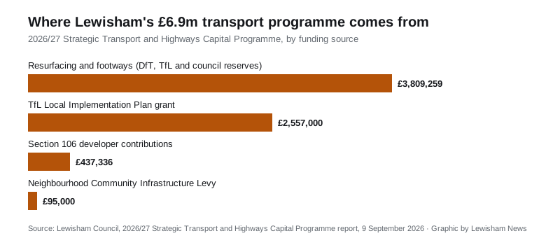
The programme draws on four pots, per the report’s funding sections:
- £3,809,259 for resurfacing and footways, of which £1,637,000 is Department for Transport highway maintenance funding, £27,000 is TfL Principal Road Renewal money, and the rest comes from the council’s capital reserves
- £2,557,000 from TfL’s Local Implementation Plan grant, confirmed in February, of which £2,325,000 is capital and £232,000 revenue. TfL’s letter said more could follow later in the year, subject to progress
- £437,336 in approved Section 106 developer contributions
- £95,000 of Neighbourhood Community Infrastructure Levy funds
The roads were prioritised using a 2024 borough-wide condition survey by Gaist Solutions, which graded every carriageway and footway from 1 to 5, with 5 the worst, refined into a costed priority list by Metis Consultants. A new survey to updated national standards runs in summer 2026 and will inform the later part of this year’s programme and 2027/28.
Sources
- 2026/27 Strategic Transport and Highways Capital Programme report, Lewisham Council, Mayor and Cabinet, 9 September 2026
- Mayor and Cabinet agenda, 9 September 2026, Lewisham Council
Have your say